![]() |
![]() |
![]()
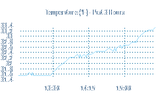
![]() Graph of various readings over the last 24 hours. Historical data can be found at Weather Underground where the wms.net weather station is also providing information for public consumption. You can download a comma separated values file of today's data here. Forecast and current condition data is provided by the National Weather Service. Here are a few various weather related pictures taken with my Canon digital camera. Hourly reports and near-term forecasts can also be subscribed to on Twitter. Follow @WoodburyMNWX.
| ![]()
![]() Rest of Tonight // Widespread showers and thunderstorms late in the evening, then showers and thunderstorms likely after midnight. Lows around 55. Southwest winds 5 to 10 MPH shifting to the west after midnight. Sunday // Cooler. Mostly cloudy with a 50 percent chance of showers and thunderstorms. Highs around 65. Northwest winds 10 to 15 MPH. Sunday Night // Mostly clear. Lows around 45. North winds 5 to 15 MPH decreasing to 5 MPH after midnight. ![]() Monday // Sunny. Highs around 70. North winds 5 MPH. Monday Night // Mostly clear. Lows around 50. Northeast winds around 5 MPH shifting to the southeast after midnight. Tuesday and Tuesday Night // Partly cloudy. Highs 75 to 80. Lows around 60. Wednesday // Partly cloudy with a 20 percent chance of showers and thunderstorms. Highs 75 to 80. Wednesday Night // Partly cloudy in the evening then becoming mostly cloudy. Showers and thunderstorms likely. Lows around 60. Chance of rain 60 percent. Thursday // Partly cloudy with a 50 percent chance of showers and thunderstorms. Highs 75 to 80. Thursday Night and Friday // Partly cloudy with a 40 percent chance of showers and thunderstorms. Lows 55 to 60. Highs 75 to 80. Friday Night // Partly cloudy with a 20 percent chance of showers and thunderstorms. Lows around 60. Saturday // Partly cloudy. Highs around 80. ![]() ![]() | ||||||||||||||||||||||||||||||||||||||||||||||||||||||
![]() |